Author: College of Engineering

Sue Hill is the Digital Content Manager for the College of Engineering.

Simon Carn on the Taal Volcano

Aerial view of the plume from the eruption.
NASA Image of Taal

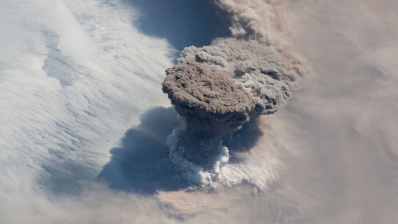
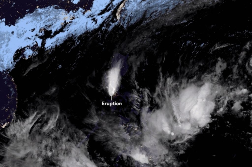
Simon Carn (GMES) was quoted in the article “Map shows Taal Volcano spewing sulfur into atmosphere,” in the Philippine Star. Carn was also quoted in “Taal volcano eruption: NASA satellite scans reveal TOXIC sulphur clouds spewing from Taal,” in the Express (UK).

Although the levels of SO2 released by Taal have so far been tolerable, Michigan volcanologist Simon Carn fears more of the toxic gas could be still be released.

He said: “However, it is possible that the Taal eruption could continue and produce more SO2 in the coming days.”

Read more at Express (UK), by Sebastian Kettley.

In the News

Simon Carn (GMES) was quoted in the story “Huge Taal volcano eruption is seen from SPACE by Japan’s satellite,” in the Daily Mail (UK).

Carn was quoted in the story “The Taal Eruption Looks Even More Massive When Seen From Space,” in spot.ph.

Shiliang Wu on Climate Temperature Inversion Trends

Shiliang Wu
Shiliang Wu

Shiliang Wu (GMES/CEE) was quoted in the story “Climate change, inversions, and the rise of ‘super pollution’ air events,” in Environmental Health News. The story was run on several outlets including The Daily Climate.

PITTSBURGH—Residents of the Mon Valley, a cluster of townships along the Monongahela River 20 miles south of Pittsburgh, Pennsylvania, endured some of the stinkiest and most polluted air in the nation this Christmas.

Some experts say that trend is likely to continue, and that cities around the world could see an influx of similar “super pollution events” as Earth continues to warm.

“For the last at least 60 years we have data for, we can clearly see a trend of increasing temperature inversions in midlatitude regions,” Shiliang Wu, an atmospheric chemist and associate professor at Michigan Technological University, told EHN. “I believe this trend will continue in the coming decades, which will likely lead to an increase in extreme air pollution episodes.”

Read more at Environmental Health News, by Kristina Marusic.

In the News

Shiliang Wu (GMES/CEE) was quoted in the article “Climate change has led to more temperature inversions and the rise of ‘super pollution events,’ in GreenBiz.

GIS Team at Coastlines and People Workshop

Daniel Lizzadro-McPherson outside showing a demo
Daniel Lizzadro-McPherson

Don Lafreniere (SS/GLRC), Ryan Williams (GLRC), Dan Lizzadro-McPherson (GMES/GLRC), and students from the Advanced GIS Methods class attended the NSF funded Coastlines and People Workshop hosted at Northern Michigan University on December 6, 2019. The Coastlines and People workshop series is working to bring scientists and stakeholders together to produce a vision for the future of sustainable coastal development in an era of dynamic climate change.

Lafreniere, Williams, and Lizzadro-McPherson introduced attendees to several projects underway at the Michigan Tech Geospatial Research Facility including the Keweenaw Time Traveler (NEH), 300 Years of Francophone Migration (SSHRC), Keweenaw Fault Mapping (USGS), and Historic Coastlines of Michigan mapping projects (EGLE). The workshop featured additional presentations from NMU and Michigan State University faculty, as well as welcome messages from the Mayor of the City of Marquette and the President of Northern Michigan University. All presentations were well received by nearly 75 attendees. Additional workshops are scheduled in 2020.

AGU Bridge Program

AGU Bridge Program showing a person walking on a natural bridgeMichigan Tech’s Department of Geological and Mining Engineering and Sciences was listed as a Bridge Program partner institution in the article “AGU’s Bridge Program Creates Opportunities for Underrepresented Students,” in Earth, Space and Science News.

In the first round of applications to the Bridge Program, AGU received 52 applications from institutions wishing to become Bridge Partners—these applicants represent 20% of the 250 active Earth and space science graduate programs in the United States. From those applications, 14 institutions were chosen as Bridge Program partners and will be featured on the AGU and AGU Bridge Program websites.

Read more at Earth, Space and Science News, by Chris McEntee.

Simon Carn Comments on the Raikoke Volcano

Raikoke Volcano plume from space.
Raikoke Volcano. Courtesy of NASA.

Earlier this year, astronauts in the International Space Station got a front row seat for an epic event, but it wasn’t happening in space. On June 22, the astronauts looked down at the earth and saw the Raikoke Volcano erupting , which led to some incredible images captured by NASA and other satellites.

“What a spectacular image. It reminds me of the classic Sarychev Peak astronaut photograph of an eruption in the Kuriles from about ten years ago,” said Simon Carn, a volcanologist at Michigan Tech, in a NASA statement about the volcanic eruption . “The ring of white puffy clouds at the base of the column might be a sign of ambient air being drawn into the column and the condensation of water vapor. Or it could be a rising plume from interaction between magma and seawater because Raikoke is a small island and flows likely entered the water.”

Read more at Men’s Journal, by Matthew Jussim.

Rose and Vye on Jacobsville Sandstone and Keweenaw Geoheritage Efforts

Jacobsville Sandstone

Research Professor Bill Rose and Geoheritage Education Coordinator Erika Vye presented the paper “UNESCO Recognition of Jacobsville Standstone as Global Heritage Stone Resource Buoys Keweenaw Geoheritage Efforts” at GSA 2019, the Geological Society of America annual meeting.

The presenters stated that the International Union of Geological Sciences (IUGS) and the United Nations Educational, Scientific and Cultural Organization’s (UNESCO’s) International Geoscience Programme (IGP) have announced that the Jacobsville Sandstone, a rock formation named for Jacobsville, Michigan, is now one of the first 15 Global Heritage Stone Resources (GHSR) in the world and the first in the United States.

They discussed the history of the natural stone in the copper country and noted the impact of international recognition upon the awareness of geoheritage.

The 2019 meeting was held September 22-25 in Phoenix, AZ.

Read more at GSA 2019.

Simon Carn on the Gigantic Pumice Raft

Simon Carn Pumice WaterIn early August, sailors in the southwest Pacific Ocean began to see their environment transmogrify. As far as the eye could see, the ocean turned from an azure delight into a colossal gathering of clinking, floating rocks. And then came the foul, sulfurous odors.

Satellite images—plenty of which were shared on Twitter by Simon Carn, a volcanologist at Michigan Technological University—showed a giant pumice raft twisting and warping in the open ocean, pushed around by the winds and waves. The raft covered an area a bit larger than San Francisco.

Read more at Gizmodo, by Robin George Andrews.

NSF Funding for Volcanic Study on Lahar Dynamics and Monitoring

William “Bill” Rose and Rüdiger Escobar-Wolf with a sample of volcanic rock.

Rudiger Escobar-Wolf (GMES/EPSSI) is Principal Investigator on a project that has received a $294,662 research and development grant from the National Science Foundation. The project is titled “Collaborative Research: Lahar Dynamics and Monitoring: A Multiparametric Approach Grounded in Infrasound.” This is a potential three-year project.

By Sponsored Programs.

Extract

Lahars, or volcanic mud flows, produce infrasound (low-frequency acoustic energy) that can be detected from distances of many kilometers. As such, it is possible to remotely characterize these hazardous mud flows by tracking their flow positions and energetics through time.

This work seeks to develop infrasound analytical tools to locate where lahars initiate, how far and fast they move, and estimate their mass flow.

Toward these goals the project will deploy and maintain seismic and infrasonic instruments at Fuego Volcano (Guatemala), where lahars are common during the rainy season (April through September). Rain gauges and time lapse cameras will be installed at locations along the lahar paths to understand how lahars initiate and to validate flow characteristics through direct observation.

This award is cofunded by the PredicMon of and Resilience against Extreme Events (PREEVENTS) program.

Read more at the National Science Foundation.

Department and Museum Represented at Institute on Lake Superior Geology

Terrace BayTed Bornhorst, A. E. Seaman Mineral Museum executive director and interim curator, and Patty Cobin, associate museum manager, attended the 65th annual Institute on Lake Superior Geology held in Terrace Bay, Ontario, May 7-10, 2019.

Cobin was registrar for the 112 attendees of the technical sessions and those who attended one or more of the 8 pre- and post-meeting field trips. Thomas Bodden, a graduate student in geological and mining engineering and sciences department, also attended the meeting. Bodden presented a poster paper, along with co-authors Bornhorst, Florence Begue of University of Lausanne, Switzerland, and Chad Deering, assistant professor, geological and mining engineering and sciences.

Bodden’s paper was titled: “Stable isotope composition of calcite precipitated with native copper and other minerals of the Keweenaw Peninsula, Michigan.” Last year Bodden was awarded a small research grant from the Institute on Lake Superior Geology. He received an Eisenbrey student travel award at the conclusion of the meeting to help defray the cost of attending the meeting.

By A. E. Seaman Mineral Museum.