Congratulations to Trista Vick-Majors and colleagues who recently published a paper titled “Constraints on the Timing and Extent of Deglacial Grounding Line Retreat in West Antarctica” in AGU Adventures.

Abstract
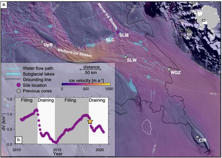
Projections of Antarctica’s contribution to future sea level rise are associated with significant uncertainty, in part because the observational record is too short to capture long-term processes necessary to estimate ice mass changes over societally relevant timescales. Records of grounding line retreat from the geologic past offer an opportunity to extend our observations of these processes beyond the modern record and to gain a more comprehensive understanding of ice-sheet change. Here, we present constraints on the timing and inland extent of deglacial grounding line retreat in the southern Ross Sea, Antarctica, obtained via direct sampling of a subglacial lake located 150 km inland from the modern grounding line and beneath >1 km of ice. Isotopic measurements of water and sediment from the lake enabled us to evaluate how the subglacial microbial community accessed radiocarbon-bearing organic carbon for energy, as well as where it transferred carbon metabolically. Using radiocarbon as a natural tracer, we found that sedimentary organic carbon was microbially translocated to dissolved carbon pools in the subglacial hydrologic system during the 4.5-year period of water accumulation prior to our sampling. This finding indicates that the grounding line along the Siple Coast of West Antarctica retreated more than 250 km inland during the mid-Holocene (6.3 ± 1.0 ka), prior to re-advancing to its modern position.