GMES Assistant Professor Xin Xi’s new open-source dataset, duISD, is featured in Michigan Tech’s Unscripted Research blog. Here, he tells us more about it.
Q: How did you get started studying dust and desertification?
XX: I grew up in humid southern China and had no experiences with dust storms when I was young. When I started college in Beijing, I had personal encounters with the “yellow dust” or Kosa (in Korea and Japan). The sky turned murky yellow every spring, while the whole city was shrouded in a cloud of dust blown from northwestern China.
When I started graduate school at Georgia Tech, atmospheric aerosols emerged as a central theme in climate research, largely because they are capable of counteracting the warming effect of greenhouse gasses and play a crucial role in the hydrological cycle. Like many others, I became interested in my research due to the positive influence of my Ph.D. advisor, an expert in atmospheric aerosols, particularly mineral dust.
Q: Why did you decide to revisit the use of horizontal visibility?
XX: Primarily because of the long timespan of the visibility record from surface weather stations. It is by far the longest instrumental data record of dust, including regions near the dust source where modern-day satellites have difficulties providing reliable observations.
Long-term, uninterrupted data records are paramount for understanding the variability of dust in response to climate and land use changes. I believe the visibility record has not been used to its full potential, so I took on the effort to develop a homogenized dust-climate record.
Q: Who do you imagine will get the most use from your new dataset? How would a researcher make use of it, and why?
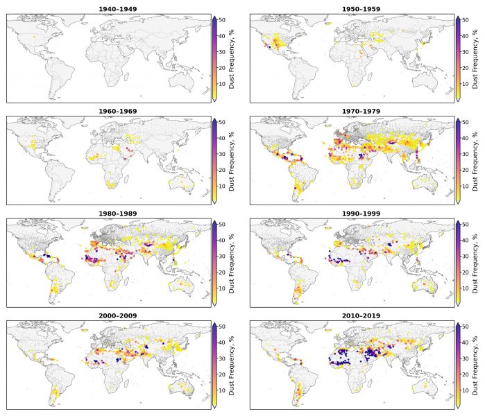
XX: This new dataset is an initial version of the dust-climate dataset I have been working on. Currently it consists of monthly records of the ambient dust burden at more than 10,000 weather stations worldwide. It is presented in an easy-to-read format, so anyone familiar with spreadsheets can use it. Dust researchers may find it useful, because they can avoid the tedious preprocessing steps with the raw data and are presented with summary statistics to help them pick the stations for their region of interest.

Q: Do you intend to update with future versions?
XX: Definitely. I plan to conduct data fusion by combining the surface observations with additional climate and land information from satellites or models.
Q: What are the most unique and noteworthy aspects of this research?
XX: It is a climate data record development project, and the ultimate goal is to create a quality-controlled dataset for the climate community to study trends, variability and relationships about dust and climate. In addition, I believe the dataset can offer other insightful information about the deficiency of current climate models.
Q: What do you plan to research next?
XX: I plan to take on the next step of updating the initial dataset I created, and develop new analytic results, which can convince myself — and, hopefully, the climate community — that surface weather observations are worth a refreshed look and can be used for improving our dust-climate modeling capability.
Xi’s open-source dataset, duISD, can be accessed online.