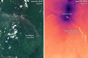
 On June 3, 2018, torrents of hot ash, rock, and gas poured down ravines and stream channels on the slopes of Volcán de Fuego—Guatamala’s Volcano of Fire. More than three weeks after the eruption, the Landsat 8 satellite continued to detect elevated temperatures in some of the pyroclastic flow deposits.
“Fuego left pyroclastic flow deposits that cooled down quickly at the surface but are still very hot inside,” explained Michigan Technological University volcanologist Rüdiger Escobar-Wolf. “Cooling deposits can show surface temperatures above the background level for a long time—weeks, or even months. However, that temperature may be only slightly above the background level, as the heat from the interior slowly seeps out of the deposit to the surface.”
Read more at NASA Earth Observatory.
New Funding
Rudiger Escobar-Wolf (GMES) is the principal investigator on a project that has received a $115,024 research and development grant from the National Science Foundation.
Simon Carn (GMES) and Michigan Tech alumna Lizette Rodriguez Iglesias, PhD ’07, are Co/PIs on the project “RAPID: Lethal Pyroclastic Density Current (PDC) Generation and Transport at Fuego Volcano.” This is a one-year project.
Extract
This Rapid Research Response (RAPID) award will be used to better understand the deadly eruption at Fuego volcano (Guatemala) on June 3rd, 2018, and in particular the pyroclastic density currents (PDCs) that caused the fatalities. How those PDCs initiated, what caused them to move that far, and what could be the conditions under which they may form in the future, are all poorly understood issues. By looking at the PDCs deposit, mapping them and study their stratigraphy in the field, analyzing the the chemical, petrological, and physical characteristics (density and vesicularity, grain size distribution, etc.), and by using numerical models to understand their flowing dynamics, this team hopes to be able to tell where the PDCs material came from, and how it was fragmented and transported. They will also look at geophysical and geochemical monitoring data leading up and during the eruption, particularly from the local seismic network and satellite remote sensing data, to characterize other aspects of the eruption as well (eruption intensity and duration) and put the PDC information in that context. This knowledge will improve our understanding of the formation of this kind of PDCs, particularly at basaltic volcanoes like Fuego, and could be relevant to many other similar volcanoes worldwide and in the US.
Related: