Category: Seminars

Rail Transportation Seminar: Railway Track Structures Research at Tampere University of Technology

sep8
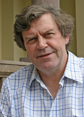
Rail Transportation Program and Environmental Engineering Geologists AEG Michigan Tech Student Chapter present Dr. Pauli Kolisoja Professor, Dept. of Civil Engineering Tampere University of Technology (TUT) in Finland presented a seminar on rail research at TUT at Michigan Tech on Monday, Sept. 9, 12-1 p.m. at DOW 875.

The title of the seminar is: “Railway Track Structures Research at Tampere University of Technology”  

Environmental Engineering Seminar: Nuts and Bolts of Unconventional Oil and Gas Development

Environmental Engineering Seminar: Nuts and Bolts of Unconventional Oil and Gas Development including all you might like to know about the technology and practice of hydraulic fracturing
Wayne D Pennington, Interim Dean, College of Engineering, Michigan Technological University
Mon Mar 24, 2014 3pm – 4pm, Dow 642
Watch the seminar Video on Vimeo: Unconventional Oil and Gas Development: Technology and Practice of Hydraulic Fracturing

Over the past couple of decades, technology has been developed to produce oil and gas from geological formations that had been overlooked previously due to the lack of appropriate engineering techniques for those types of formations. As a result, the energy picture for the USA and for the world has been seriously modified, and the impact is being felt.  

Seminar: Ice, Rocks, and Robots, Oh My!–Paving the Yellow-Brick Road to Europa

Department of Geological and Mining Engineering and Sciences Seminar
Friday, March 21, 3:05-3:55 pm, Dow 610
Ice, Rocks, and Robots, Oh My!–Paving the Yellow-Brick Road to Europa
Victoria Siegel, Ph.D. Student
GMES, Michigan Technological University
Astrobiologists agree that Jupiter’s moon Europa is one of the most promising places where our solar system might harbor life (besides Earth, of course). Data from Galileo and Hubble’s recent images of possible water vapor plumes escaping from Europa’s surface suggest that a liquid water ocean lies concealed beneath the moon’s thick ice shell. Over the past ten years, NASA has funded several projects to investigate autonomous systems we might use to explore this strange and challenging environment. As they are developed, these robots are put to good, practical use in terrestrial Europa-analog environments. From an Alaskan glacier, to flooded sinkholes in Mexico, to an ice-covered sea in Antarctica, these ‘bots are helping us explore, map, and understand extreme environments and life forms on Earth–all the while bringing us closer to making Europa sub-surface exploration a reality. If you think the Curiosity Rover is wild (it is), come see what planetary exploration could look like in the future.

Environmentally and Socially Responsible Mining Presentation

Hannah White, public outreach manager at Northwest Mining Association, a national nonprofit, nonpartisan trading association representing the entire mining life cycle, from exploration to reclamation and closure. Their purpose is to advocate and advance, educate, and foster and promote environmentally and socially responsible mining. She spoke to students in a seminar on November 19th. More info

GMES Seminar: Linking mantle dynamics to plate tectonics

GMES Seminar: Linking mantle dynamics to plate tectonics

Trond H. Torsvik, Centre for Earth Evolution and Dynamics (CEED), University of Oslo, 0316 Oslo, Norway; Friday, November 1, 2013, Dow 610

The calibration of longitude in the mid-eighteenth century by the invention of a sea-going chronometer gave mariners confidence that they could reliably calculate their absolute position on the Earth’s surface. Until recently, Earth scientists have been in the comparable position of having no way of calculating the longitudes of continents before the Cretaceous, leaving paleomagnetism, which cannot determine longitude, as the only quantitative means of positioning continents on the globe before that time. However, by choosing a reference continent that has moved the least longitudinally (i.e. Africa), longitudinal uncertainty can be minimized. The analytical trick is to rotate all paleomagnetic poles to Africa and calculate a global apparent polar wander path in African co-ordinates, which serves as the basis for subsequent global reconstructions. This method is dubbed the ‘zero-longitudinal motion’ approximation for Africa, and has allowed us to confidently estimate true polar wander (TPW) since Pangea formation (320 Ma), and to demonstrate that ancient large igneous provinces and kimberlites have been sourced by plumes from the edges of the large low shear-wave velocity provinces (LLSVPs) on the core-mantle boundary beneath Africa and the Pacific. Using this surface-to-CMB correlation and a new iterative approach for defining a palaeomagnetic reference frame corrected for TPW, we have developed a model for absolute plate motion back to earliest Paleozoic time that maintains the remarkable link between surface volcanism and the LLSVPs. For the Paleozoic we have for the first time identified several phases of slow, oscillatory TPW (less than 1 degree/Myr) during which the Earth’s axis of minimum moment of inertia was similar to that of Mesozoic times. We model ten phases of clockwise and counter-clockwise rotations since 540 Ma, which can be interpreted as oscillatory swings approximately around the same axis (11 degrees East at equator). Net TPW angles peaked at 22 degrees in the Mesozoic and 62 degrees in the Paleozoic, and paleomagnetic and TPW-corrected (mantle) reconstructions therefore differ significantly in the early Paleozoic.

Link

Seminar: Oil Spill Response Experience: Exxon Valdez to BP Deepwater Horizon

In an engaging lecture, Tina Behr-Andres will share her experience advising the Federal Government’s Science Team for the Deep Water Horizon BP Oil Spill Response. The presentation, entitled, “Oil Spill Response Experience: Exxon Valdez to BP Deepwater Horizon,” will be held on Tuesday, April 23, from 4 p.m. to 5p.m., Dow 642.

Behr-Andres holds over twenty years of professional experience in engineering academe, private-sector technical consulting and national laboratory research management. She specializes in management of legacy wastes from nuclear weapons production; marine and terrestrial oil spill response; industrial and hazardous waste management and wastewater treatment; and contaminated site remediation. Currently, Behr-Andres is an Executive Advisor to the principal associate director of science, technology and engineering at Los Alamos National Laboratory.

This presentation is sponsored by Los Alamos National Laboratory, the Sustainable Futures Institute, Michigan Tech’s Department of Geological and Mining Engineering and Sciences, and Michigan Tech’s Office for Institutional Diversity.

Seminar: ‘Lessons from Yucca Mountain Standards, Regulations & Performance Assessments

Professor Rodney C. Ewing, Edward H. Kraus Distinguished University Professor
Department of Earth & Environmental Sciences, University of Michigan
‘Lessons from Yucca Mountain Standards, Regulations & Performance Assessments”
Yucca Mountain, Nevada, was scheduled to be a geological repository storage facility for high-level radioactive waste until it was defunded in 2010. This seminar is sponsored by the A. E. Seaman Mineral Museum and hosted by the Department of Geological and Mining Engineering and Sciences. There will be a social after the talk in the Dow sixth-floor atrium (lakeside).
Friday – March 22, 3:00 to 4:00 pm DOW 642; Social to follow in 6th floor atrium, lakeside

Seminar: Patty Bryan, Principal Geologist/Senior ProjectManager, URS Corporation

Patty Bryan, Principal Geologist/Senior ProjectManager, URS Corporation – hosted by Association of Environmental and Engineering Geology (AEG) URS Corporation is an engineering, design and construction firm and a US federal government contractor. Bryan will present a technical talk on URS projects and describe opportunities for engineering. Seminar was presented as part of National Engineers Week, Friday February 15, 2013


Thomas Oommen Assistant Professor, Geological and Mining Engineering and Sciences presents a gift of native copper to Patty Bryan.

GMES Seminar: Cable Shovel Durabaility in Formation-Excavation Engineering

GMES Seminar: Cable Shovel Durability in Formation-Excavation Engineering
Muhammad Azeem Raza, Instructor, GMES, PhD Candidate of Mining Engineering

Cable shovel is a primary excavation unit in many surface mines around the world. The capacities of the shovels have seen an ever increasing trend to achieve the economies of large scale operation. The modern day shovels have 100+ tons per pass production capacities. The dynamic force of 100+ ton material combined with the dynamic cutting, friction and acceleration forces during the excavation result in severe stress loading of the shovel front end components. Stress and fatigue cracks appear, as a result of this cyclic stress loading, resulting in expansive breakdown, reduced efficiency and production loss. Numerical and analytical techniques can be used to model the stress and fatigue failures.
In this seminar we will discuss the challenges and on-going research in cable-shovel formation-excavation and durability studies. The talk will include: (i) kinematic and dynamic modeling of shovel, (ii) stress and fatigue failure modeling (iii) life expectancy of shovel front-end components.

Muhammad Azeem Raza, an instructor for GMES, will be presenting his work titled “Cable Shovel Durabaility in Formation-Excavation Engineering”. Mr. Raza is a PhD candidate for a degree in Mining Engineering at the Missouri University of Science and Technology, Rolla. He is also an assistant professor at the University of Engineering and Technology, Lahore where he taught for three years before coming to the US for his PhD.

EPSSI Speaker: Integrating ecosystem modeling and remote sensing to understand effects of hypoxia on the food web in the Northern Gulf of Mexico

December 3, 2012: Integrating Ecosystem Modeling and Remote Sensing to Understand the Effects of Hypoxia on the Food Web in the Northern Gulf of Mexico. Andrea Vander Woude. Cooperative Institute for Limnology and Ecosystems Research;
4 pm, M&M Room U113
Dr. Andrea Vander Woude will be next week’s EPSSI seminar speaker. She is currently a Postdoctoral Researcher at the Cooperative Institute for Limnology and Ecosystem Research (CILER) and NOAA’s Great Lakes Environmental Research Labratory (GLERL). Andrea works in the fields of remote sensing and ecosystem modeling of the Great Lakes and coastal ocean. Her seminar is titled, “Integrating ecosystem modeling and remote sensing to understand effects of hypoxia on the food web in the Northern Gulf of Mexico.”

Abstract: The Northern Gulf of Mexico (NGOMEX) experiences extensive seasonal hypoxia that is predicted to cause declines in the production of commercially and recreationally valuable fish and shellfish. In order to understand the direct and indirect effects of hypoxia on food web dynamics and ecological and economically important species, we developed an Atlantis ecosystem model and compared the model results to the available satellite remote sensing data. The Atlantis framework is a three-dimensional biogeochemical and biophysical modeling system that uses hydrodynamic model output as a forcing function and simulates biochemical cycles and food web interactions. Nutrient and field observations from 2003-2008, and from Southeast Area Monitoring and Assessment Program (SeaMap) were used to initialize the Atlantis ecosystem-based model and the in situ data were also compared to salinity, temperature and chlorophyll values from the available satellite imagery. This included coincident satellite data from the Aquarius satellite (salinity) the Moderate-resolution Imaging Spectroradiometer (MODIS) and the MEdium Resolution Imaging Spectrometer (MERIS). The output of the NGOMEX Atlantis model helped define the extent and seasonal timing of hypoxia on predator-prey interactions and directional change in the food web components. Our overall goal is to use these results to forecast the effects of hypoxia on NGOMEX living resources by uniquely combining both satellite and ecosystem based model results.