Despite broad understanding of volcanoes, our ability to predict the timing, duration, type, size, and consequences of volcanic eruptions is limited, says a new report by the National Academies of Sciences, Engineering, and Medicine. Meanwhile, millions of people live in volcanically active areas around the world.
Volcanic Eruptions and Their Repose, Unrest, Precursors, and Timing (ERUPT) identifies grand challenges for the scientific community to better prepare for volcanic eruptions. Michigan Tech volcanologist Simon Carn (GMES) was an author on the report, and served with 11 other volcanologists and scientists on the Committee on Improving Understanding of Volcanic Eruptions that prepared the report. Their goal: improving eruption forecasting and warnings to save lives.
According to the NAP media release on the report, “Volcano monitoring is critical for forecasting eruptions and mitigating risks of their hazards. However, few volcanoes are adequately observed, and many are not monitored at all. For example, fewer than half of the 169 potentially active volcanoes in the US have any seismometers–an instrument to detect small earthquakes that signal underground magma movement. And only three have continuous gas measurements, which are crucial because the composition and quantity of dissolved gases in magma drive eruptions. Enhanced monitoring combined with advances in experimental and mathematical models of volcanic processes can improve the understanding and forecasting of eruptions.”
“This report was requested by NASA, NSF and USGS, the three main sources of funding for volcano science in the US, to identify some of the grand challenges in the field,” says Carn. “It was a privilege to serve on this distinguished committee and help craft a document that we hope will guide and strengthen future research efforts in volcanology.”
“The National Academies convenes committees of experts to review the current understanding of pressing issues and identify priorities for future progress in addressing the issues,” adds Michigan Tech Department Chair John Gierke (GMES). “Committee reports play important roles in formulating government policies and setting priorities for funding scientific research. Dr. Carn is a global leader in remote sensing for monitoring volcanic emissions and surely contributed a comprehensive assessment of the state of knowledge and recommend how different disciplinary fields could bring new perspectives and approaches to advance the understanding of volcanic hazards.”
Electronic (free) and hard copies ($40) of Volcanic Eruptions and Their Repose, Unrest, Precursors, and Timing are available online. More information is available in the NAP media release about the report.
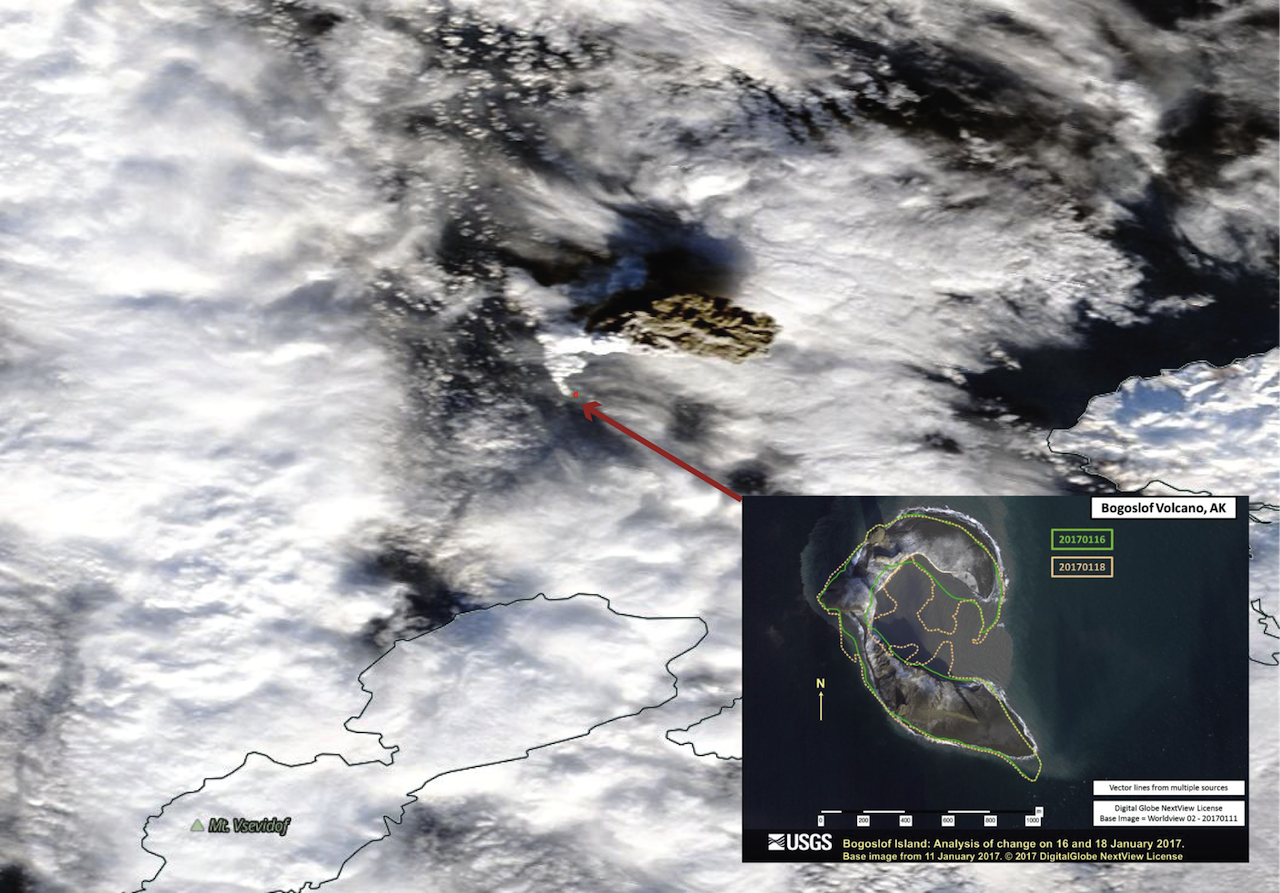
The 2016– 2017 Eruption of Bogoslof Volcano, Aleutian Islands, United States
Bogoslof, a remote, mostly submarine volcano in the Aleutian Island arc began erupting in late December 2016 and activity continues as of February 2017. The Bogoslof eruption highlights several of the challenges facing volcano science. Over one month, the volcano produced numerous explosions with plumes rising 20,000–35,000 ft, posing a significant hazard to North Pacific aviation. There are no ground-based instruments (e.g., seismometers) on the volcano, and so the USGS Alaska Volcano Observatory (AVO) has been relying on distant seismometers, satellite data, infrasound, and lightning detection to monitor activity (Challenge 3). Bogoslof’s submerged vent obscures any preemptive thermal or gas signals, and infrasound and lightning are detectable only after eruptions have begun (Challenge 1). AVO has been unable to provide early warning of these hazardous events. The eruption also highlights our limited understanding of magma–water interactions and raises important questions regarding the controls on phreatomagmatic explosivity, column altitude, ash removal, and pauses (Challenge 2). In more than 20 discrete events, the emerging volcano has reshaped its coastlines repeatedly, providing snapshots of volcano–landscape interactions. The figure below shows the first evidence for an ash-rich (brown-grey) plume, almost one month into the eruptive activity.
Excerpted from Volcanic Eruptions and Their Repose, Unrest, Precursors, and Timing, National Academies of Sciences, Engineering, and Medicine, April 2017