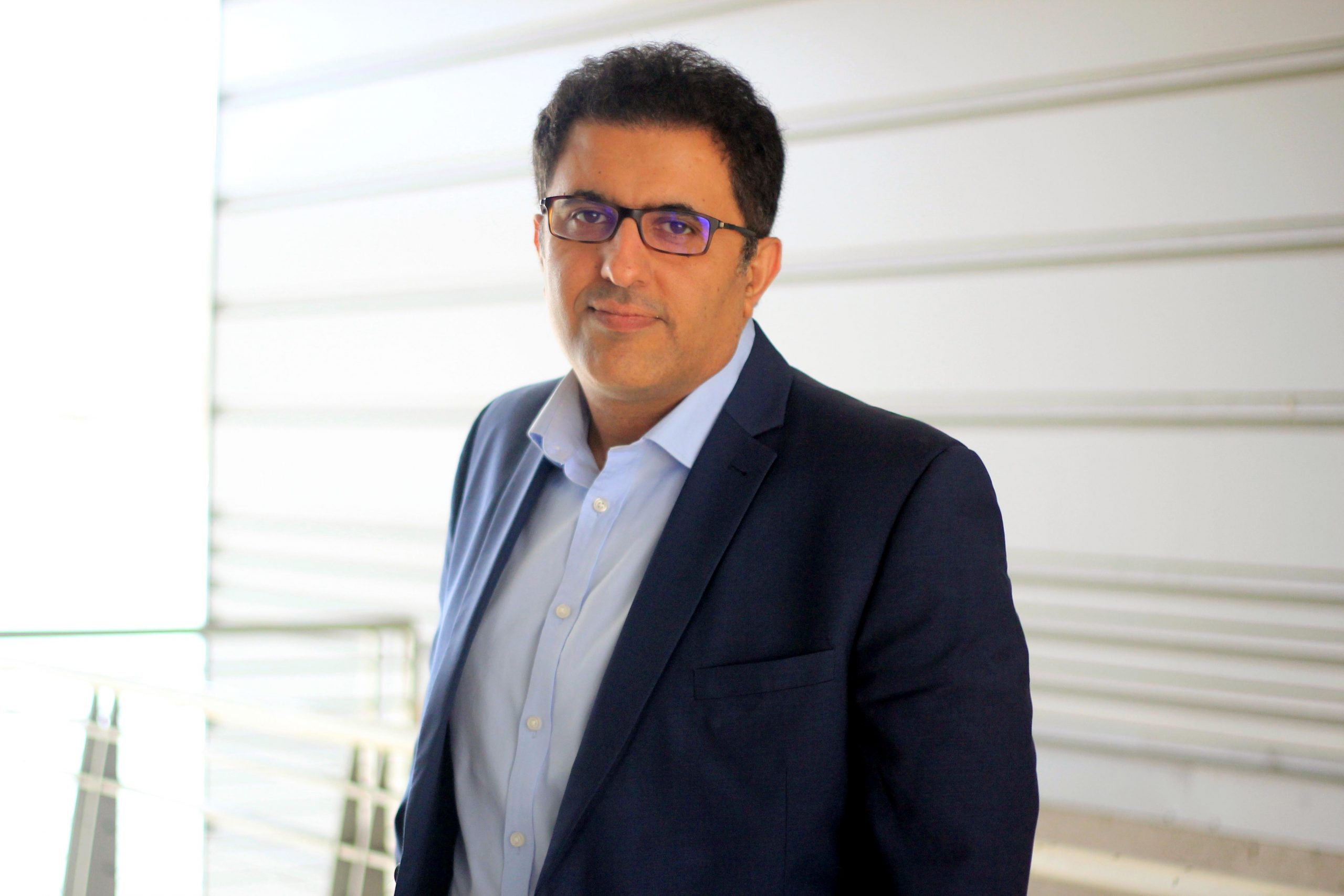
Category: Faculty

GMES Expands into Drone-Based Geophysics: A New Frontier for Education and Research

(left to right) PhD candidate Gabriel Ahrendt, undergraduate researcher Miah Mol, and MS student Samuel Jensen from the Earth and Environmental Magnetism research group are gearing up our drone-based geophysics platform for its next test flight.

The Department of Geological and Mining Engineering and Sciences (GMES) at Michigan Technological University is always looking for opportunities to expand our education and research into new, forward-looking areas. Drone-based geophysics is one such area—an emerging field that is rapidly transforming how we investigate and understand the subsurface.

Drone-based geophysics offers remarkable potential for geoscience and engineering practice. By
combining unmanned aerial systems with advanced geophysical sensors, we can safely and efficiently
collect high-resolution data in challenging or previously inaccessible environments. These capabilities
are reshaping mineral exploration, environmental assessment, hazard mapping, and infrastructure
monitoring.

To provide our students with this increasingly sought-after skill set — valued across industry, government agencies, and research organizations — we have launched the development of a new drone-based geophysics curriculum. To support this initiative, the department has acquired a high-capacity Aurelia X6 Pro V2 drone paired with a Geometrics MagArrow II magnetometer, one of the most advanced airborne magnetic systems available. This effort is currently led by Professor Aleksey Smirnov, chair of GMES, together with MS student Samuel Jensen. Both have recently completed comprehensive training and earned professional unmanned aerial vehicle pilot licenses, ensuring safe and compliant deployment of these systems in research and instructional settings.

Sam Jensen and Aleksey Smirnov prepare a drone for its first outdoor flight, with tall trees in the background.
Sam Jensen and Aleksey Smirnov are preparing for the first flight of the Aurelia X6 Pro drone equipped with the Geometrics MagArrow II magnetometer.

Our vision is to develop a suite of drone-based geophysics courses covering not only airborne data acquisition but also advanced data processing and visualization. Students will use the state-of-the-art Seequent Oasis Montaj geophysical software — recently acquired to support the Applied Geophysics program — to work with real flight datasets, learn industry-standard workflows, and build strong practical expertise.

Our future research directions include a wide range of potential applications, such as high-resolution magnetic mapping of Precambrian rocks in the Upper Peninsula of Michigan, critical minerals and geological hydrogen exploration, surveys of mine tailings and legacy mining landscapes for environmental and safety assessments, geologic mapping of fault zones and structural features, and magnetic mapping for archaeological investigations.

We are also actively seeking collaborations with other departments and research centers at Michigan Tech, as well as partners outside the university, to broaden the impact and interdisciplinary reach of this developing program.

Looking ahead, we plan to expand our toolkit with additional drone-compatible geophysical methods, including electromagnetics and ground-penetrating radar, further enhancing opportunities for education and research.

We are excited about the hands-on learning and research possibilities that drone-based geophysics will offer, and we hope that this work will inspire more students to join GMES and contribute to the continued success of the department. Stay tuned for updates…

Dr. Yanrui (Daisy) Ning Joins the GMES Faculty

The Department of Geological and Mining Engineering and Sciences at Michigan Technological
University is pleased to welcome Dr. Yanrui (Daisy) Ning as the newest member of our faculty in
Geological Engineering. Dr. Ning brings extensive experience and technical expertise that will
strengthen the department’s teaching and research portfolio in subsurface energy systems and
resource engineering.

Dr. Ning earned her Ph.D. in Petroleum Engineering from the Colorado School of Mines in 2017,
where she also served as a Research Assistant Professor in the Department of Geophysics. Her
research focuses on carbon capture, utilization, and storage (CCUS), enhanced geothermal
systems, subsurface hydrogen storage, and critical minerals. She applies an integrated approach
that combines multiphase flow modeling, geomechanics, advanced computational simulation,
machine learning, and distributed fiber-optic sensing to advance the understanding and
sustainable management of subsurface energy systems.

In her new role at Michigan Tech, Dr. Ning will contribute to both teaching and research in
support of the Geological Engineering program. Her expertise in subsurface energy systems
directly supports the national priorities of strengthening U.S. energy security, expanding
domestic resource production, and ensuring a stable supply of critical minerals. She is also
advancing emerging fields such as geological hydrogen exploration and carbon management,
which align with the nation’s goals of responsible resource development and technological
innovation in the energy sector.

“Dr. Ning’s expertise in subsurface energy systems and her multidisciplinary approach
will enhance our capabilities in critical areas such as carbon storage, geothermal
energy, critical minerals, and geological hydrogen,” said Aleksey Smirnov, Chair of the
Department of Geological and Mining Engineering and Sciences. “We are excited to
have her on board as we continue to grow our Geological Engineering program and
expand our impact on the sustainable development of Earth’s resources.”

Please join us in welcoming Dr. Daisy Ning to Michigan Tech and the GMES community.

Dr. Radwin Askari: Pioneering Geophysics Research and Education at Michigan Tech

Dr. Askari

Dr. Radwin Askari, Associate Professor in the Department of Geological and Mining Engineering and Sciences (GMES) at Michigan Tech, is a geophysicist at the forefront of environmental geophysics and energy transition research. His innovative work focuses on understanding fluid transport in geological settings and its geophysical signatures, including volcanic tremors and long-period events. As the founder of Michigan Tech’s state-of-the-art Physical Modeling Laboratory (PML) in Dow 622, Dr. Askari leads pioneering research on environmental geophysics, fracture dynamics and its induced seismicity, and geological hydrogen. His lab is equipped with advanced technologies such as acoustic velocity, low permeability, ultrasonic, and high-speed imaging systems, providing students with exceptional opportunities for hands-on learning.

Dr. Askari fosters a diverse and inclusive research environment, welcoming students from all backgrounds to contribute to groundbreaking work that impacts environmental conservation and the global energy transition. He is also a recipient of the prestigious NSF CAREER award, further highlighting his commitment to both research and education. Join Dr. Askari at Michigan Tech, where you can be part of transformative research addressing some of the world’s most pressing challenges in geophysics and energy.

Dr. Askari directs the Earth Explorers Computer Lab (EECL) Dow 619. A multifunctional hub, EECL supports GMES students’ research, coursework, and senior projects with high-performance workstations, specialized software, and access to Michigan Tech’s computing cluster. It also features a TV screen and videoconferencing equipment and serves as a classroom and meeting space, all within a refreshed and collaborative environment.

Dow 619 Earth Explorers Computer Lab (EECL)

Since Dr. Askari joined in 2015, GMES has benefited from his expertise, which he has since taught courses such as Fundamentals of Geophysics, Computational Geosciences, Environmental and Engineering Geophysics, Reflection Seismology, Formation Evaluation and Petroleum Engineering, Advanced Engineering and Engineering Geophysics, and Advanced Reflection Seismology. Be sure to check out the educational videos Dr. Askari creates and shares on his YouTube channel!

Are you ready to explore groundbreaking research and hands-on learning? mtu.edu/apply

Breeanne Heusdens, Fletcher McGuire ‘22, Olivia Salvaggio ‘22, Sananda Ray, Nontawat Srisapan, Radwin Askari

Leading the Charge in Climate Science: Join Dr. Xin Xi at Michigan Tech

Dr. Xin Xi is excited to mentor and collaborate with the next generation of scholars.

Dr. Xin Xi is at the forefront of climate science, and Michigan Tech offers the chance to be part of his transformative work. Focusing on the life cycle of atmospheric aerosols and their far-reaching impacts on ecosystems, air quality, and climate, Dr. Xi tackles critical global challenges such as desertification and air pollution through remote sensing, in situ measurements, and advanced modeling techniques.

Dr. Xi and his team address pressing environmental and human health issues by combining cutting-edge research with innovative approaches. Supported by prestigious grants, including NASA’s LCLUC program, Dr. Xi’s work is shaping the future of climate science and inspiring the next generation of problem-solvers.

Going back to the vault, in this MTU research blog, Dr. Xi explains how airborne dust aerosols impact the Earth in various ways and shares how he believes the surface synoptic observations have not yet been used to their full potential, leading him to develop a unified dust-climate data record.

Since joining Michigan Tech, Dr. Xin Xi has significantly contributed to geoscience education, teaching advanced geoinformatics courses, introduction to GIS, and Python programming for geosciences. His Geoinformatics Graduate Certificate is widely recognized for its excellence and relevance in preparing students for the demands of modern geospatial research and industry applications.

Join Michigan Tech, where Professor Xi leads, and you excel.

MTU campus viewed from across the frozen snow-covered canal.
Michigan Technological University campus as viewed from across the frozen Portage canal.

Small but Mighty: GMES Department at Michigan Tech Earns AGU Bridge Program Recertification

The Michigan Technological University campus before sunset on a summer evening, as seen from the vantage point of Mont Ripley’s front yard with purple lupins in the foreground.
MTU campus before sunset on a summer evening, as seen from Mont Ripley’s front yard.

We are thrilled to announce that the Department of Geological and Mining Engineering and Sciences (GMES) at Michigan Technological University has been awarded recertification in the prestigious American Geophysical Union (AGU) and Inclusive Graduate Education Network’s (IGEN) Bridge Program. This recognition underscores our commitment to fostering a diverse, equitable, and inclusive community in the Earth and space sciences.

The AGU Bridge Program plays a crucial role in broadening participation in geosciences by supporting underrepresented students as they pursue graduate studies. Through this partnership, our department continues to create an environment where all students can thrive, innovate, and contribute meaningfully to the field.

What does recertification mean? Recertification is a testament to the strength of our program and the dedication of our faculty, staff, and students. Acceptance decisions were based on a rigorous external review, annual reports, and evaluations by Bridge Program staff. These assessments highlighted the strengths of our application and offered valuable feedback to guide us in planning for the next five years.

Our renewed partnership extends through December 31, 2029. Along with the recertification, we’ve committed to:
– Mentorship Training—Faculty involved in the Bridge Program will undergo mentorship training to ensure we continue providing our students with the highest level of support.
– Student Support Through Graduation—We pledge to support all current and future students admitted through the Bridge Program, even beyond the duration of our partnership.

These new requirements align with the Bridge Program’s evolving practices and reinforce the shared mission to empower underrepresented students in geosciences.

This recertification is a significant milestone for a small department within a large engineering school. It reflects our ability to maintain high standards and our passion for cultivating an inclusive and supportive academic community. We are proud to stand alongside other Bridge Program institutions in advancing diversity and equity in the geosciences.

This achievement would not have been possible without the hard work and dedication of the GMES faculty and staff, as well as the incredible students who make our department so vibrant and inspiring. Together, we are shaping the future of Earth and space sciences! Are you ready? Apply now.

Preserving Historic Copper Mining Records

Boxes of historical data ready to join the digital era.

Preserving historic copper mining records is at the heart of an exciting new project at Michigan Tech! Led by James DeGraff, GMES Research Professor, a team of researchers has secured $118,898 in matching grant funding from the National Park Service (NPS) to archive records through advanced digitization.

Titled “Preservation, Indexing, and Enhanced Utility of Historic Copper Mining Drill Hole Records,” the project is part of the NPS Save America’s Treasures Grant Program, which is dedicated to safeguarding the nation’s cultural heritage. Established in 1988 to celebrate America’s premier cultural resources, Save America’s Treasures grants this year funded 59 projects through the Historic Preservation Fund that will preserve nationally significant sites and historical collections in 26 states and the District of Columbia.

The team will digitize and organize records from over 650 drill holes from 1899 to 1970, creating an interactive map that will be accessible to the public. Copper mining on the Keweenaw Peninsula dates back more than 8,000 years, but an influx of miners in the 1800s—spurred by technological advances and rising demand for copper—made the region a hotbed of activity.

Man stands on dock with stacked copper ingots. A nearby sign reads, “This copper for shipment.” Photo courtesy of Michigan Tech Archives 2017.

Congratulations to DeGraff and his co-investigators—Lindsay Hiltunen (VPOL), Don Lafreniere (SS/GRF), and Erika Vye (GLRC)—on this impactful initiative! The copper mining records hold significant historical and scientific value. They showcase the evolution of drilling technology and geology while contributing to current efforts to secure critical minerals from domestic sources.

Diamond Drill Hole Records

Meet Professor Shiliang Wu

Professor Wu

Discover the fascinating work of Professor Shiliang Wu, a leading expert in atmospheric chemistry and air quality at Michigan Tech! As a key faculty member in the Departments of Geological and Mining Engineering & Sciences and Civil, Environmental, and Geospatial Engineering, Professor Wu conducts groundbreaking research at the intersection of air quality, climate, wildfires, and ecosystems. He maps the global journey of air pollutants through sophisticated computer modeling, revealing their impact on our environment and health. Take advantage of this opportunity to dive into the science driving cleaner air and a healthier planet!

Figure 1 shows a comprehensive global view of arsenic levels in surface air for 2005. This map integrates sophisticated modeling with measurement data from monitoring stations worldwide, clearly depicting annual average arsenic concentrations. Color gradients represent background arsenic levels, while station locations are marked by circles, directly comparing model predictions and field data. This visualization underscores the global distribution of arsenic in the air, highlighting critical areas of environmental health concern and bridging scientific modeling with real-world impacts.

Figure 1. Arsenic concentrations in surface air. Model-simulated annual (for the year 2005) mean arsenic concentrations in ambient air (background) compared with measurement data at various stations (circles) around the world.

SME Features Michigan Tech in Magazine Series on US Mining Schools

Quincy Mine

The Society for Mining, Metallurgy & Exploration (SME) featured Michigan Tech in Part 3 of its series on U.S. mining engineering schools, published in the September 2024 issue of Mining Engineering Magazine, the society’s official publication. The profile spotlighted the mining-related degree programs Michigan Tech’s Department of Geological and Mining Engineering and Sciences (GMES) offered.

The article included Q&A sessions with Aleksey Smirnov, GMES professor and department chair; senior mining engineering student Alice Schmaltz; and recent graduates Emily Voght (B.S. Mining Engineering, 2022) and Jacob Maxon (B.S. Mining Engineering, 2023).

In his interview, Smirnov highlighted Michigan Tech as the only U.S. college to offer mining and geoscience-related programs within a single department. He emphasized the University’s proximity to active mining projects, hands-on learning opportunities in mine safety, critical minerals, and data analytics, and the strong industry connections that provide students with internships and job prospects.

Welcome to Our New Assistant Professor, Dr. Xiang Li

xiang li
Dr. Xiang Li

We are pleased to welcome Dr. Xiang Li as the newest member of our faculty in the Department of Geological and Mining Engineering and Sciences at Michigan Tech. Dr. Li brings valuable experience and knowledge that will significantly contribute to our department’s goals in geological engineering.

Dr. Li received his PhD in Geotechnical Engineering from Northwestern University in 2022. His primary research interests lie in geological and geotechnical modeling, with a focus on the dynamics of landslides triggered by precipitation. Before joining Michigan Tech, Dr. Li was a Postdoctoral Scholar at the University of California, Los Angeles, where he expanded his expertise by advancing geomechanics theory through the use of large datasets acquired via Interferometric Synthetic Aperture Radar (InSAR) remote sensing. This approach not only enables the acquisition of large-scale ground deformation data to refine and improve models but also offers future applications in soil-structure interaction, coastal infrastructure resilience, and earthquake engineering. Recently, Dr. Li published a lead-author paper in the prestigious journal Geophysical Research Letters.

In his new role, Dr. Li will be actively involved in teaching and research in support of our Geological Engineering program. With his expertise and innovative research approach, Dr. Li is poised to play a key role in shaping the future of our program, driving forward our commitment to excellence, and expanding our impact in the field. We look forward to the contributions he will bring to our department. Please join us in welcoming Dr. Li to our department and the university.