Above: A high-resolution, drone-captured image of seagulls gathering on the beach in St. Ignace, Michigan.
Dr. Parth Bhatt is definitely making his mark at Michigan Tech’s College of Forest Resources and Environmental Science. Arriving in only 2016, he quickly earned both his master’s degree and then his doctorate from the CFRES. And on important projects, too. That is, during his PhD, he worked with the Nature Conservancy and the U.S. Forest Service to map the Hiawatha National Forest according to its natural habitat communities. To do so, he used both sensing and machine learning techniques.
But this was not his first use of machine learning to depict and analyze complex natural phenomenon. Before coming to Tech, Parth Bhatt worked with the Indian Space Research Organization (ISRO).
Currently, Parth (which he prefers to be called) is a Teaching Assistant Professor / Researcher in the CFRES, who has a passion for Python, remote sensing, and more.
Recently, I’ve collaborated with him to help promote his courses and to grow with Global Campus.
Discovering Python’s Capabilities
But let’s take a step back for a second. Despite his current expertise in and enthusiasm for Python , it was at Michigan Tech that Parth first developed his passion for this programming tool.
As an MS student, he took the class Python Programming for ArcGIS. Here, he learned more about Python and applying some of its techniques to automate repetitive tasks. Impressed with this tool, Parth then attended a GIS conference in which he saw people using Python in almost every field. At this event, he thought to himself, “I need to get better at this.” So he buckled down on his studying, taking in several NASA sponsored online webinars.
And get better he did. And quickly!
He ended up teaching several courses at the undergraduate and graduate level. He was enthusiastically in the classroom for Introduction to GIS, Introduction to GIS for Natural Resources Management, GIS Project Management, and Seminar in GIS.
It is obvious that Parth is a very busy and motivated professional. That is, he is currently instructing a non-credit, 7-week course (Python for Modern GIS and Remote Sensing). And while doing so, he is also developing a for-credit graduate certificate for Spring 2024.
Because this programming language is his passion, I asked him to explain it to me.
Q. Summarize Python for a layperson.
A. Python is a popular programming language for making a person’s day to day work/research life easier and efficient. It has gained widespread popularity in the past decade. Overall, it is extremely useful in the field of GIS and Remote Sensing (or any field for that matter) due to its dynamic nature, ease of use, and versatile, large open community support.
Q. What distinguishes Python from other programming languages when it comes to being used in GIS environments?
A. Well, as I said before, Python is easy to use and implement. It is also very efficient and powerful for data visualization and processing.
Due to Python’s open-source nature, it can be combined with all the major GIS softwares like ArcGIS Pro, ArcGIS Online, QGIS etc. Therefore, it offers a great amount of working flexibility. And from a developer’s perspective, all the major advances are occurring within Python, as compared to other languages such as R. Over the last decade, Python has emerged as a winner in terms of the most liked and used programming languages by the GIS community.
Q: What excites you about applying Python in GIS environments? What is this tool best used for? How have you used it?
A. The possibilities are endless. Python can be used in anything from opening a simple excel sheet filled with various GIS data to visualizing, manipulating, and handling big data. It also has hundreds of useful libraries that are applicable for various geospatial analysis. To me, any modern GIS and Remote Sensing curriculum is incomplete without this language and tool.
In my work, I have used Python to automate various GIS tasks: updating a dataset attribute table with hundreds of rows and columns (basically data cleaning); classifying complex forest ecosystems using machine learning; as well as analyzing data, making charts, conducting accuracy assessments, and performing various geospatial analysis tasks. Furthermore, I have assessed change in terms of urbanization, detected algal blooms, and calculated fire burn ratios.
Q. You’re teaching a non-credit course “Python for Modern GIS and Remote Sensing.” Please briefly explain what this course is about and who should take it.
A: I’m excited about this course, which is new to Michigan Tech. No one has taught Python for GIS in either an online or non-credit format before.
In a nutshell, this course teaches beginning and intermediate-level Python skills as they are applied in the GIS environment. It is suitable for anyone who deals with (or is planning to deal with) GIS and Remote Sensing on a daily basis. Of course, anyone who wants to add to their skill set and make their work more efficient should take it.
As you know, Coding/Programming is an essential skill set to have in our current times, especially for fields such as GIS, Forestry, Ecology, Geology, Civil and Environmental Engineering, and Data Science.
For example, right now in my course, I have students from diverse backgrounds, as well as professionals working in the GIS Industry. They are enjoying the asynchronous class format and the assignments. I am looking forward to incorporating their feedback in the next edition of the course, which will be in Spring 2024.
On a broader scale, Python is basically used in every application that’s related to the the five earth elements (Air, Water, Land, Fire, and Space). For example, it’s playing a big part in NASA’s first ever Mars drone application
Q. How can professionals use Python to manage or solve prevailing environmental and sustainability challenges, such as land use, forest fires, and the effects of climate change?
A. Python offers hundreds of unique libraries, which can be implemented to any/all kind of GIS and Remote Sensing datasets. Developers can make useful tools according to their needs and applications. As a result, they can enhance their decision making processes.
For example, professionals at the multidisciplinary Michigan Tech Research Institute (MTRI) use Python programming to address complex ecological problems, make wildfire prediction models, analyze efficient road networks, asses infrastructure, and map and monitor land use/cover and pristine wetlands.
Overall, this is an exciting time to teach this course. We are living in a world where climate change is happening rapidly and things surrounding us are constantly changing (whether they are environmental, economical, or political).
Q. I agree that we need all hands on deck when it comes to solving climate change and sustainability issues. But what is a personal example of your use of Python to contend with pressing environmental problems?
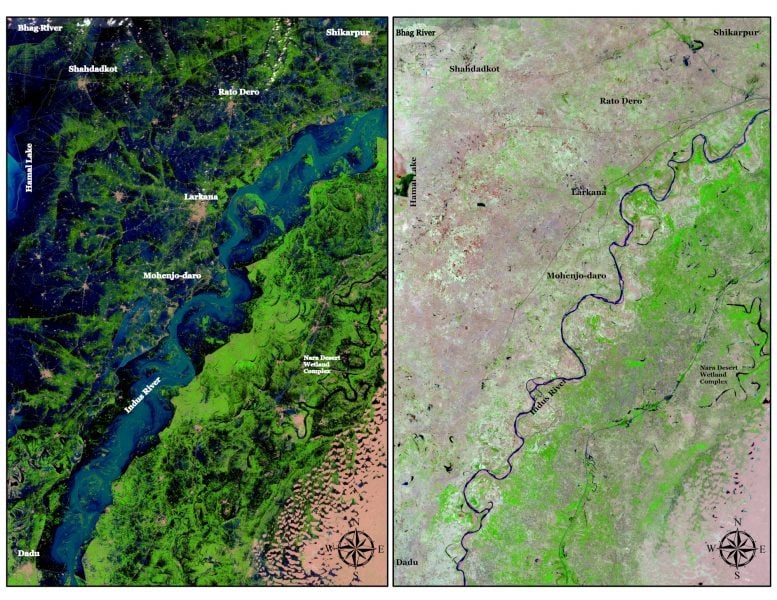
In my own work, I have used this tool to document the effects of the historic flood in Pakistan. The flood, which was in mid-June ’22, affected more than 33 million people and destroyed or damaged more than one million houses.
In fact, the floods affected all four of the country’s provinces or about 15% of the country’s population.
Floodwaters inundated tens of thousands of square kilometers of the country, causing at least 1,100 deaths. Because of the 2023 monsoon season, Pakistan is still struggling to recover from this event.
Q. What motivates you? And what is next on your journey at Michigan Tech?
A. I love teaching, doing research, and solving complex problems. These drives require me stay current with, if not slightly ahead of, my field. Furthermore, I believe that if I am not up to date with my knowledge, I won’t be able to offer anything new and beneficial to students.
As Gandhi so eloquently said, “You must be the change you wish to see in the world.” In other words, I have to keep updating and offering advanced skills, not only for my personal growth, but also for students so they can succeed in their careers.
And for the College of Forest Resources and Environmental Sciences, I’m glad to help grow its online offerings. My non-credit course marks the beginning of our online education program. That is, we are designing other useful and applied courses, such as ArcGIS Online. Also, starting in 2024, we plan to be offering the first ever Master’s of Geographical Information Science online degree certification. Look out for it on Michigan Tech’s Global Campus.
One more thing: I’m holding an information session on Oct. 20 at 10:30 AM for Carthage College in Kenosha, Wisconsin. The session will introduce the Online GIS programs from the CFRES. However, the Michigan Tech community is also welcome to attend. You will be asked to sign in with your MTU email (or the email associated with your Zoom account) to join the session. If you have any questions about this session or anything else, email me at ppbhatt@mtu.edu.
Q. Any final thoughts?
As excited as I am about learning new materials and tools, the biggest reward of teaching occurs when you run into or hear from a student and they say, “Thank you for teaching me that GIS thing, it’s helping me big time in my job or research.”