Day: June 21, 2018

Vote for the Whiz Kids tonight (Thurs. June 21) by 8:30 pm

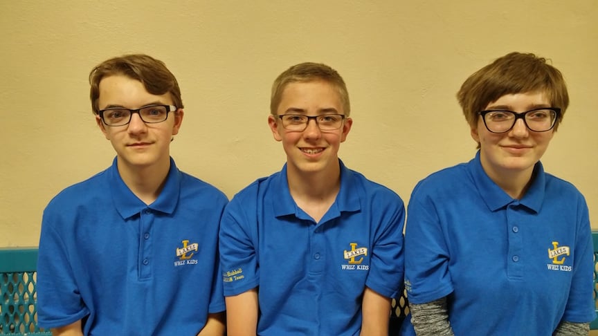
The Lake Linden Whiz Kids eCybermission team along with advisors Engineering Fundamentals Senior Lecturer Gretchen Hein & 4th year chemical engineering student Ryan Knoll are in Washington DC this week. They will present their findings about using stamp sand in lightweight concrete. The presentations can be watched live and you can vote for their team for the People’s Choice Award.

 Voting is from 1:30-8pm today. They would love your support. The link is: http://ecyber18.hscampaigns.com/#9thgradeteams

They will be receiving a STEM in Action Grant Award tomorrow to continue their work and will be meeting with the EPA on Monday to discuss their project.  The meeting with the EPA would never have happened without help from Representative Jack Bergman. The team thanks the College of Engineering,  Chemical Engineering and Engineering Fundentals for their support.

Read past stories about the team here.

Lake Linden Whiz Kids

Mapping Lahar Threats in the Aftermath of Volcán de Fuego

Preliminary mapping lahar threats in Guatemala—vital for communities affected by the eruption.
Michigan Tech Geophysicist, Volcanologist Rudiger Escobar Wolf
Volcanologist Rudiger Escobar Wolf

In the aftermath of the eruption of Volcán de Fuego in Guatemala, the risk now is for lahars triggered by extreme rain events. Guatemala’s rainy season started in May and typically runs through the month of October. Lahar hazards are the result of fresh (loose) eruptive deposits on steep slopes that experience heavy rainfall, creating mud and debris flows that can scour landscapes and inundate lower lying areas. The hazards are exacerbated by the steepness of the slopes, recent loss of vegetation, and the rainy season.

Rudiger Escobar Wolf, a volcanologist at Michigan Technological University and native of Guatemala, shares a set of preliminary crisis hazard maps of the threat of lahars at Fuego volcano in Guatemala, created with INSIVUMEH, Guatemala’s Instituto Nacional de Sismologia, Vulcanologia, Meterologia e Hidrologia, as well as USGS/VDAP, and others.

Volcanological information: Preliminary map of threat by lahars with scenarios of moderate and intense rainfall.

VOLCANO DE FUEGO: @insivumehgt unveils a preliminary map of threat by lahars with scenarios of moderate and intense rains.

Lahars often initiate at upper most elevations and flow down through stream channels and gullies. Scientists forecast lahar hazards using computer models of the slopes in conjunction with estimates of the lahar volume at the outset, which is very challenging to estimate. For instance, in October 2005, Santa Ana erupted in El Salvador and lahars from this fresh ash were triggered overnight due to Hurricane Stan. And in November 2009, Hurricane Ida triggered devastating lahars from San Vicente volcano. Those deposits were from a large eruption of a nearby Ilopango Volcano that occurred more than 1500 years prior and had been sitting precariously on the slopes of San Vicente until 36″ of rain fell in 18 hours.

Escobar Wolf has worked on the most active three volcanoes in Guatemala (Fuego, Pacaya, and Santaguito) since he was a little boy. Michigan Tech Volcanology Professor (Emeritus) Bill Rose and others worked with him as a young adult and recruited him to Michigan Tech for graduate studies. Escobar Wolf is in frequent communication with CONRED (sort of like FEMA) and INSIVUMEH (sort of like USGS) about the eruptive symptoms of Guatemala’s active volcanoes.

As a PhD student in 2010 Rudiger Escobar Wolf outlined volcanic risks and the benefits of an early warning system to (now former) Guatemalan Vice President Dr. Rafael Espada, and Alejandro Maldonado, executive secretary of CONRED.

The eruptive activity of Fuego Volcano is so frequent, in fact, it is the classic “cry wolf” scenario.

“Most volcanoes are either ‘on’ or ‘off’, but Fuego has been simmering since 1999,” says Kyle Brill, a doctoral candidate in geophysics at Michigan Tech. Brill also monitors seismic activity at Fuego Volcano. “Less than one percent of the volcanoes around the world have had eruptions lasting longer than a decade, and Guatemala has three volcanoes that always seem active to some level,” he says. “Questions naturally arose in hindsight in the days following the eruption as to why people around Fuego didn’t receive/heed evacuation warnings earlier, and the answer to that, sadly, was that Fuego is so active normally that it is very difficult to forecast when changes in activity could become deadly.”

Brill is a returned Peace Corps volunteer. He served in Guatemala under the Environmental Conservation and Income Generation Program as a Master’s International student in the Mitigation of Natural Geologic Hazards program at Michigan Tech.

Kyle Brill on Pacaya Volcano
Kyle Brill on Pacaya Volcano, Guatemala

Despite the frequent eruptive behaviors, aspects of this eruption were much different than recent events at Fuego. In particular, some of the pyroclastic flows overbanked the drainages.

NPR’s Here & Now on WBUR-FM features an interview with Rudiger Escobar Wolf, Ph.D. ’13, MS ’07, talking about the Volcán de Fuego eruption. Listen at “Rescue Operations Underway In Guatemala After Deadly Volcano Eruption

Find out more about lahars from the USGS Volcano Hazards Program

Check out drone footage taken one week after the eruption of Volcán de Fuego, by Jozef Stano