 Dulcinea Avouris’s, who was advised by Simon Carn (GMES), lead research published in the journal Geology and was highlighted in a Focus article along with a news brief in EARTH Magazine.
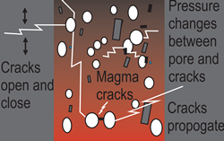
What effects do earthquakes have on volcanoes?
The interaction between earthquakes and volcanoes intrigues the public and provides a complex and cascading hazard that challenges scientists across a spectrum of disciplines. The key to understanding earthquake-volcano interactions is the response of gas and magma to earthquake-imposed stresses.