Category: Research

GMES People Attend the Annual Meeting of ILSG in 2023

Eau Claire picture of the waterfront and city buildings.
Eau Claire, Wisconsin, by Itrytohelp32. This file is licensed under the Creative Commons Attribution-Share Alike 4.0 International license.

Michigan Tech was well represented at the 69th annual meeting for the Institute on Lake Superior Geology (ILSG), held in Eau Claire, Wisconsin, from April 23-26.

Research Professor Jim DeGraff and Professor Emeritus Bill Rose (GMES) presented a poster titled “Digital Image Capture and Database Compilation of Historical Mining Data from the Keweenaw Copper District, Michigan: A Progress Update.”

Graduate student Katherine Langfield (geology) delivered an oral presentation titled “Slip Kinematics of the Keweenaw and Hancock Faults within the Midcontinent Rift System, Upper Peninsula of Michigan.”

Graduate student Daniel Lizzadro-McPherson (geology) delivered an oral presentation titled “Structural Analysis and Slip Kinematics of the Keweenaw Fault System between Béte Grise Bay and Gratiot Lake, Keweenaw County, Michigan.”

Rose also delivered an oral presentation titled “New Work Developing Geoheritage Awareness.”

Geosciences Research Scientist Erika Vye (GLRC/GMES) delivered an oral presentation titled “Geoheritage as an Educational Tool to Explore Relationships with Land and Water in the Keweenaw.”

Professor Emeritus Ted Bornhorst (GMES) presented Peter Hollings, professor at Lakehead University in Thunder Bay, Ontario, with the prestigious ILSG Goldich Medal recognizing outstanding contributions to the understanding of Lake Superior geology. He also attended the ILSG Board of Directors meeting; the board approved the 70th annual meeting to be held in Houghton in 2024, which will be chaired by Bornhorst.

The ILSG is a nonprofit professional society that provides a forum for promoting better understanding of the geology of the Lake Superior region. The major activity of the institute is an annual meeting with geological field trips and technical presentations.

Gierke and Bowman on Building Rainwater Collection Systems

Group of locals and two researchers standing outside
Fundación Cartagena Nuevo Amanecer project partners celebrating the completion of another phase of their demonstrative community garden in Magangue, Colombia. Image courtesy of Damaris Guerra.
Man standing near a tank holding a sticker with  mining picks and a Husky illustration.
Foundation’s lead technician Jesus Fandiño with a GMES sticker to be placed on the main rainwater catchment/irrigation supply tank.

John Gierke and Luke Bowman supported Fundación Cartagena Nuevo Amanecer, with Dr. Gierke serving as Small-Scale Irrigation Systems Expert and Dr. Bowman serving as Water Capture (Hydrology) Specialist.

The two assisted the Fundación in the design of a small-scale water catchment and irrigation system for FCNA’s school garden beds as well as local backyard gardens.

In addition to designing and building functional systems during 10 days of work, Gierke and Bowman provided community partners with user-friendly, Spanish-language, spreadsheet tools to explore design considerations for sizing, purchasing components, and building new systems.

Read more at Partners of the Americas Economic Development & Health, by Farmer.to.Farmer.POA.

Simon Carn on the Shiveluch Volcanic Eruption

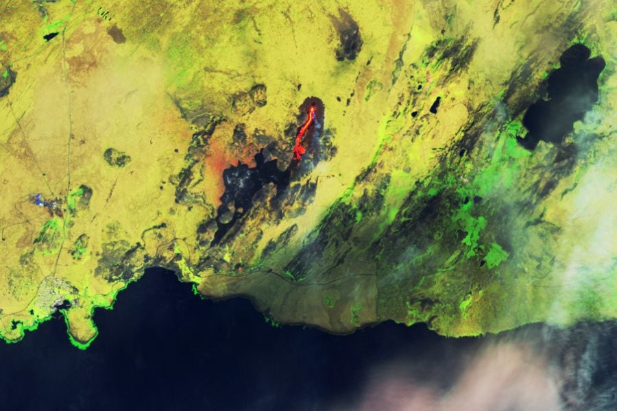
Satellite view of the peninsula with orange coloring.
Kamchatka Peninsula with Shiveluch in the upper, right quadrant. Image taken on April 11, 2023, by NASA Earth Observatory.

Simon Carn was quoted by the Washington Post in a story about the eruption of Russia’s Shiveluch volcano, located on the Kamchatka Peninsula in Russia’s far east. The story was picked up by MSN and the Benzie County Record Patriot.

The incident “looks like the largest Shiveluch eruption of the satellite era,” Michigan Technological University volcanologist Simon Carn said on Twitter.

Carn is a professor in the Department of Geological and Mining Engineering and Sciences with a PhD in Volcanology from Cambridge University. His current research focus is the application of remote sensing data to studies of volcanic degassing, volcanic eruption clouds, and anthropogenic pollution.

A Fresh Perspective: GMES Freshman Shines in Hydrological Research

Meet Natalie Sorensen, the exceptional first-year student at the Department of Geological and Mining Engineering and Sciences (GMES) who has defied the odds and conducted scientific research during her freshman year. Natalie’s project focused on helping farmers adjust their farming practices based on water availability, which is dictated naturally by climate and enhanced anthropogenically. She worked closely with Dr. John Gierke to test the Mark 2 soil moisture sensor against independent measurements of meteorological parameters and soil moisture in a local agricultural setting.

Student standing in the field with two apparatuses.
The HOBO station is on the left, and Arable Mark 2 is on the right.

Natalie’s project was a rare feat for a freshman, as most students don’t join research until their junior or senior years. However, Natalie’s passion and dedication to the field drove her to take on this challenge early in her college career. Natalie compared data from an Arable Mark 2 weather station to data from a HOBO RX3000 weather station, which is commonly used in climate-monitoring research. To independently test the soil moisture sensors on both weather stations, she also took soil core samples to measure soil moisture using gravimetric analysis. While the results of Natalie’ study are still being analyzed, the preliminary data seem promising and compatible with the natural variability of soil properties in glacial settings.

Student in the field taking core samples near an instrument.
Natalie takes core samples for gravimetric analyses.

Natalie’s work was supported by the URIP program and Dr. Gierke’s Institutional Research and Development (IRAD) for matching funds. In addition, in-kind support for the fieldwork was provided by the Gierke Blueberry Farm. Natalie presented a poster of her work at the Undergraduate Research Symposium on March 24, 2023, where she impressed her peers and professors with her research.

Natalie’s story is a testament to the power of hard work, passion, and dedication. She is a shining example of how early exposure to research opportunities can help students achieve their academic and professional goals. We look forward to hearing more about Natalie’s future research endeavors and wish her continued success in her studies within GMES.

Natalie Sorensen standing near her poster on the floor of the symposium.
Natalie at her poster at the Undergraduate Research Symposium.

Poster Extract

Field Testing of Climate and Soil Moisture Monitoring in an Agricultural Setting

Student Presenter: Natalie Sorensen, Geological Engineering
Faculty Advisor: John Gierke, Geological and Mining Engineering and Sciences

Farmers need to adjust their farming practices based on water availability, which is dictated naturally by climate and enhanced anthropogenically.

Data from a Mark 2 was compared to data from a HOBO RX3000 weather station (Onset, Bourne, MA), which is commonly used in climate-monitoring research, on the Gierke Blueberry Farm for the past decade.

I am still processing data to compare the Arable Mark 2 and HOBO measurements of air and soil temperatures and precipitation (along with solar intensity, atmospheric pressure, and relative humidity–the Mark 2 is not equipped to measure wind).

Read more in the URSS Booklet.

Thomas Oommen on the Slow-moving Portuguese Bend Landslide

Land near the shore showing cracks and buckling.
By Pricetveyron – Own work, CC BY-SA 4.0, https://commons.wikimedia.org/w/index.php?curid=47502552

Thomas Oommen (GMES) was quoted by SFGATE and the Seattle Times. Both outlets picked up a March 6, 2023, Los Angeles Times story about the slow-moving Portuguese Bend landslide affecting the city of Rancho Palos Verde in southern California.

Palos Verdes Peninsula has long been prone to landslides, and the most dramatic one is affecting Portuguese Bend, an area named after a Portuguese whaling operation. The geological phenomenon has hit a 240-acre area hard over the last seven decades, causing fissures to open in the earth and homes to strain, buckle and drift, sometimes outright wandering onto adjacent properties.

The land moves sometimes horizontally, sometimes vertically. Sometimes inches, sometimes feet.

Thomas Oommen, professor of geological sciences at Michigan Technological University, said it’s an interesting case study because there are only a few landslides with such significant movement every year. What distinguishes Portuguese Bend is that the slope has not failed catastrophically — yet — and the humans atop are largely staying put, riding the slow-moving land for as long as they can.

Oommen’s research efforts focus on developing improved susceptibility characterization and documentation of geo-hazards, such as earthquakes and landslides.

Read more at the Los Angeles Times, by Jack Flemming.

International Team Analyzes Ice Cores to Calculate Levels of Sulfate Aerosols

An international team which includes Simon Carn analyzed layers of an ice core from central Greenland to calculate levels of sulfate aerosols between the years 1200 and 1850. They discovered that non-erupting volcanoes leak sulfur at up to three times the rate previously believed.

https://doi.org/10.1029/2022GL102061

The discovery impacts efforts to model past, present, and future climate.

“We found that on longer timescales the amount of sulfate aerosols released during passive degassing is much higher than during eruptions,” said first author Ursula Jongebloed, a UW doctoral student in atmospheric sciences. “Passive degassing releases at least 10 times more sulfur into the atmosphere, on decadal timescales, than eruptions, and it could be as much as 30 times more.”

Read more at UW News, by Hannah Hickey.

Related

Simon Carn on the Tonga Eruption

Simon Carn (GMES) was a guest on a BBC Science In Action podcast episode on January 5, 2023, titled “One year on from the Tonga eruption.”

The episode discussed what made the January 2022 eruption of the Hunga Tonga-Hunga Ha’apai volcano so powerful and unpacked its long-lasting impacts.

“Amongst all the material ejected by Hunga Tonga was a huge amount of water. The massive water vapour cloud is still present in our atmosphere, as Professor Simon Carn from the Michigan Technological University tells us.”

BBC Science in Action

Simon Carn on the Mauna Loa Volcano Eruption

Great @planet imagery from December 1 showing #MaunaLoa #lava flows crossing the road to the @NOAA_ESRL Mauna Loa Observatory (home of the @Keeling_curve), and the active Fissure 3 with its gas plume and shadow. At this time the active flow front was ~5 km from the Saddle Road. For more posts like this, follow Prof. Simon Carn on Twitter, @simoncarn.

The world’s largest active volcano—Hawaii’s Mauna Loa—has been quiet for the past four decades. But in November 2022, the volcano began to stir.

Some cloud cover on November 28 scattered light from the eruption and urban areas and made it more diffuse. “It also looks like the lava emitted by the eruption was so bright that the sensor was saturated, producing a ‘post-saturation recovery streak’ along the VIIRS scan to the southeast,” noted Simon Carn, a volcanologist at Michigan Tech. “These streaks are only seen over very intense sources of visible radiation.”

“The eruption is effusive rather than explosive, although its initial phase overnight on November 28 was quite energetic and injected some sulfur dioxide to high altitudes, possibly all the way to the tropopause,” said Carn. “That is unusual for this type of eruption.”

Read more at NASA Earth Observatory, or follow Simon Carn on Twitter, @simoncarn.

Related

Q&A with Xin Xi: Uncovering Global Dust-Climate Connections

Dr. Xin Xi: “Surface weather observations are worth a refreshed look and can be used for improving our dust-climate modeling capability.”

GMES Assistant Professor Xin Xi’s new open-source dataset, duISD, is featured in Michigan Tech’s Unscripted Research blog. Here, he tells us more about it.

Q: How did you get started studying dust and desertification? 

XX: I grew up in humid southern China and had no experiences with dust storms when I was young. When I started college in Beijing, I had personal encounters with the “yellow dust” or Kosa (in Korea and Japan). The sky turned murky yellow every spring, while the whole city was shrouded in a cloud of dust blown from northwestern China. 

When I started graduate school at Georgia Tech, atmospheric aerosols emerged as a central theme in climate research, largely because they are capable of counteracting the warming effect of greenhouse gasses and play a crucial role in the hydrological cycle. Like many others, I became interested in my research due to the positive influence of my Ph.D. advisor, an expert in atmospheric aerosols, particularly mineral dust. 

Q: Why did you decide to revisit the use of horizontal visibility? 

XX: Primarily because of the long timespan of the visibility record from surface weather stations. It is by far the longest instrumental data record of dust, including regions near the dust source where modern-day satellites have difficulties providing reliable observations. 

Long-term, uninterrupted data records are paramount for understanding the variability of dust in response to climate and land use changes. I believe the visibility record has not been used to its full potential, so I took on the effort to develop a homogenized dust-climate record.

Q: Who do you imagine will get the most use from your new dataset? How would a researcher make use of it, and why? 

XX: This new dataset is an initial version of the dust-climate dataset I have been working on. Currently it consists of monthly records of the ambient dust burden at more than 10,000  weather stations worldwide. It is presented in an easy-to-read format, so anyone familiar with spreadsheets can use it. Dust researchers may find it useful, because they can avoid the tedious preprocessing steps with the raw data and are presented with summary statistics to help them pick the stations for their region of interest.

Dr. Xi used the dataset to characterize dust variability and climate connections around the world. The results of his study are featured in an article in the Journal of Geophysical Research: Atmospheres

Q: Do you intend to update with future versions? 

XX: Definitely. I plan to conduct data fusion by combining the surface observations with additional climate and land information from satellites or models.

Q: What are the most unique and noteworthy aspects of this research? 

XX: It is a climate data record development project, and the ultimate goal is to create a quality-controlled dataset for the climate community to study trends, variability and relationships about dust and climate. In addition, I believe the dataset can offer other insightful information about the deficiency of current climate models. 

Q: What do you plan to research next? 

XX: I plan to take on the next step of updating the initial dataset I created, and develop new analytic results, which can convince myself — and, hopefully, the climate community — that surface weather observations are worth a refreshed look and can be used for improving our dust-climate modeling capability.

Xi’s open-source dataset, duISD, can be accessed online

GMES Professors Ranked Among the Top Scientists in 2022

Numerical indices support what every volcanologist knows: Bill Rose ranks among the top scientists in 2022. Research.com compiles and analyzes publication data, including citations and h-index of scholars worldwide. In the Earth science field, over 6,400 scientists were evaluated, and professor emeritus Bill Rose is ranked 97th in the U.S. and 179th globally.

Bill came to Michigan Tech after obtaining his Ph.D. in geology at Dartmouth College. His graduate studies included field studies of active volcanoes across Pacific Latin America. The eruption of Mt. St. Helens in 1980 brought his expertise to the forefront in the US, and the geology graduate program grew in terms of number and reputation. His entire career, save for sabbaticals, has been at Michigan Tech, where he has supervised 23 Ph.D. and 57 M.S. students. He has authored and co-authored over 200 publications, which as of this ranking, were cited in more than 16,000 other publications, yielding an h-index of 81.

Bill served as chair of the GMES department from 1990 to 1998. After returning to faculty full-time, he led the development of two international programs that greatly impacted the international reputation of the department. Every volcano observatory in the US has Ph.D. scientists on staff who are former students of Bill. If you walk into a volcano observatory around the world wearing a Michigan Tech emblem, invariably, someone will ask if you “know Bill Rose.”


Professor Simon Carn in the field at Kilauea volcano (Hawaii) in 2018 (with lava in the background).

Also recognized for his contributions to Earth sciences is GMES professor, Simon Carn, who is ranked 849th in the U.S. and 1,929 globally. Simon’s work has 8,021 citations in the areas of volcanology, remote sensing, and volcanic degassing.

https://research.com/scientists-rankings/earth-science